But before I did that I had to find my way from Lake Mackenzie Dam to Ironstone Hut at Lake Nameless.
It was almost humorous as my first navigational challenge was finding the start of the actual track!
Which going by this sign I did.
Once up on the dam wall you walk around the edge of Lake Mackenzie and do a bit of rock hopping until you get to the end and start to head into the scrub.
It was at this stage I managed to follow the wrong track and ended up down the wrong little river but I bashed my way through some dense scrub and crossed a couple of smallish rivers and eventually found the track proper a bit higher up.
(I did this walk in March 2015, but I am only adding it to my blog on Feb 2016. As I type there is a massive bushfire in this very area and all the vegetation you see in these photos is now destroyed)
I follow the well formed track until I cross Explorer river and head around Lake Explorer.
I sat on the edge of Lake explorer and had a very basic lunch consisting of the cheese and salami inside wraps.
After Lake Explorer the track basically disappears but you can see Snake Lake and then 'feel' Lake Nameless in the distance so it is easy enough to navigate your way in the direction you know you need to go.


So only a few hours into the walk and with rain just starting to spit on me, I found my way to Ironstone Hut and the edge of Lake Nameless.
The rain got heavier and even though it was only mid afternoon I decided to settle in for the evening seeing as it appeared I had the hut to myself.
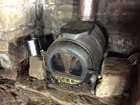
People leave quite a bit of junk in these huts for some reason but it is still nice enough and given the fire which you are allowed to use it is certainly cosy.
The view from the Hut door.
So i spent the evening in the warm hut, had tea and a few drinks, listened to some music and read some of my book.
Here is a pretty boring Youtube video of Day 1 ;)
__________________________________________________________________
Day 2 I awoke to beautiful blue skies in anticipation of what is ahead.
I was up at sunrise so I took as many phone pics as I could!
A quick time lapse experiment.
So after I packed up I was excited to try and find my way across to Middle Lake.
I started by walking over a little boulder field and edging around Forty Lakes Peak but still getting enough elevation to see the large amounts of Lakes I had to negotiate.
I won't bore you with too many details but it was just a matter of heading in the general direction of Middle Lake. The terrain is quite easy to navigate and luckily Fisher River was crossable.
So here are some pics of the journey across to Middle lake.
And not too many hours later I had Middle Lake in my sights :)
This little fellow gave me a bit of a startle!
There were some Packs and gear on the Lakes edge so even though I couldn't see anyone I am sure they must have been around somewhere.
I soon found the Blue Peaks Track that would lead me back to the car and headed along it.
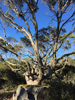
I am quite certain these stands of native pines are now burnt and will never regenerate.
I love these old moss covered markers for some reason.
Not too long and I had Lake Mackenzie in my sights.
I made it back to the car safely and feeling pretty pleased with myself for my first solo off track walking adventure.
Here are a couple of stat pics.
And the second Video showing Day 2.


0 comments:
Post a Comment